Why Mount Bromo Remains Active Yet Welcomes Visitors
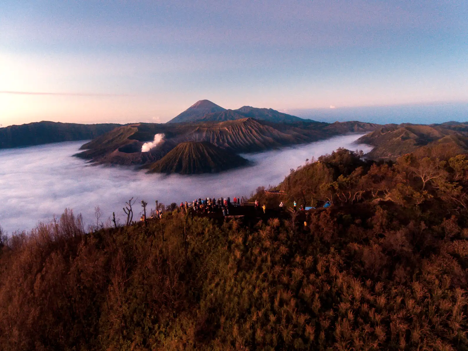
Mount Bromo remains a primary destination for travelers because its activity is strictly monitored by the Center for Volcanology and Geological Hazard Mitigation (PVMBG), allowing for safe access during non-eruptive phases. While the volcano constantly emits sulfurous smoke and occasional ash, a robust system of seismographs and exclusion zones ensures that tourism only continues when volcanic tremors remain within manageable levels.
What You Need to Know
- ✅ Current Status: Usually maintained at Level II (Alert), meaning visitors can typically reach the crater rim unless sudden activity spikes occur.
- ✅ Monitoring: 24/7 surveillance by local volcanologists at the Ngadisari observation post tracks every seismic hiccup.
- ✅ Safety Gear: Masks are often necessary due to high sulfur concentrations near the vent.
- ✅ Expert Access: Booking a professional Mount Bromo tour ensures you receive real-time safety updates from guides in contact with rangers.
Table of Contents
- The Geological Pulse of East Java
- How Authorities Manage Volcanic Risks
- Understanding the Bromo Alert Levels
- The Reality of Eruption History
- Who Should Skip This Experience?
- Practical Logistics and Timelines
- Frequently Asked Questions
The Geological Pulse of East Java
Active volcanoes define the landscape of Indonesia, sitting directly on the volatile Ring of Fire. Mount Bromo stands out because it is located inside the massive Tengger caldera, a prehistoric volcanic basin that spans ten kilometers.
Unlike dormant peaks, this vent continuously exhales white steam and sulfurous gases. Experts classify it as a cinder cone, characterized by its distinctive “broken” top and steep sides formed by accumulated volcanic debris.
Tectonic plates grinding beneath the Java Sea fuel this constant thermal energy. Pressure builds periodically, but the open nature of the vent usually allows gas to escape without massive explosive force.
The Mechanics of a Living Vent
Magma sits relatively close to the surface here, heating groundwater to create the iconic steam plumes. This hydrothermal activity creates a dynamic environment where the landscape can change slightly after heavy rains or small tremors.
Sulfur deposits often crystallize around the inner rim, creating yellow patches against the grey ash. While the sight is impressive, the smell of rotten eggs serves as a constant reminder of the chemical reactions happening just below your feet.
Safety depends on the “open” status of this plumbing system. If the vent becomes blocked, internal pressure rises, which is why volcanologists monitor gas composition and ground swelling with extreme precision.
How Authorities Manage Volcanic Risks
Responsibility for visitor safety falls upon the PVMBG and the Bromo Tengger Semeru National Park office. These agencies work in tandem to balance economic tourism with public health and safety protocols.
Observation posts located in the village of Ngadisari use digital seismographs to detect tremors invisible to humans. These tools provide an early warning system that can trigger a closure of the crater trek within minutes if necessary.
Physical barriers and signage mark the boundaries of safe exploration zones. Rangers patrol the Sea of Sand, ensuring that tourists do not wander into restricted areas during periods of increased degassing.
🔥 Featured Expedition
Discover the raw power of the Tengger Caldera with a guided trek that prioritizes safety and local expertise. Our team monitors seismic reports daily to ensure your journey to the rim is both thrilling and secure.
Real-Time Data and Digital Alerts
Technology has revolutionized how Mount Bromo safety is handled. Satellite imagery now tracks thermal anomalies that might indicate rising magma levels long before an eruption begins.
Local guides receive updates via mobile networks, allowing them to adjust itineraries before guests even leave their hotels. This level of coordination is why the park remains open for the vast majority of the year without incident.
Information gain for travelers comes from understanding these invisible safeguards. Knowing that experts are watching every tremor allows you to focus on the sunrise rather than the risks.
Understanding the Bromo Alert Levels
Indonesia uses a four-tier alert system to communicate the status of its volcanoes. Bromo spends most of its life at Level I (Normal) or Level II (Waspada/Alert), which allows for regular tourism activities.
Level II indicates that volcanic activity is above baseline levels but confined to the crater. During this phase, authorities may implement a 1-kilometer exclusion zone around the active vent while still allowing views from Penanjakan hill.
Level III (Siaga) is a more serious state where tourism is usually suspended. At this stage, the risk of ash showers and volcanic bombs becomes too high for public access, prompting immediate evacuation of the caldera floor.
Safety Guidelines for Visitors
Standard Mount Bromo visitor rules require staying on the designated concrete stairs when climbing to the rim. Attempting to walk around the narrow, unshielded parts of the crater edge can be dangerous due to loose volcanic gravel.
Carrying a respirator or a heavy-duty N95 mask is a practical necessity for anyone with sensitive lungs. Winds can shift suddenly, blowing thick clouds of sulfur dioxide directly across the viewing platforms.
Respecting the “Red Zones” is non-negotiable. These areas are calculated based on historic blast radiuses and gas accumulation patterns that can prove fatal if ignored.
The Reality of Eruption History
Historical data shows that Bromo erupts frequently but typically with low explosivity. Phreatic eruptions, caused by steam pressure rather than fresh magma, are the most common type of event recorded here.
Major events occurred in the early 2010s, coating nearby villages in thick layers of grey ash. Agriculture usually suffers during these times, but the volcanic soil eventually becomes incredibly fertile, sustaining the local Tenggerese people.
Recent activity has been limited to minor ash puffs that rarely disrupt flight paths at Surabaya Airport. These small releases of energy are actually beneficial, as they prevent the build-up of extreme pressure that could lead to a massive explosion.
Learning from Past Events
Safety protocols evolved significantly after past eruptions. Better communication channels between the national park and international aviation authorities now ensure that ash clouds are tracked in real-time.
Travelers should review the Bromo eruption history to understand the cyclical nature of this mountain. It is a “living” landscape that breathes, and its periodic restlessness is part of its natural lifecycle.
Preparedness beats panic every time. Understanding that an “active” status doesn’t mean “imminent explosion” is key to enjoying the East Java highlands without unnecessary anxiety.
Who Should Skip This Experience?
While Bromo is accessible to many, it is not an environment suited for everyone. The combination of high altitude, volcanic gases, and steep, uneven terrain presents specific challenges that require an objective assessment of your health.
- People with Chronic Respiratory Issues: If you suffer from asthma, COPD, or severe allergies, the sulfur dioxide concentrations at the crater rim can trigger immediate distress. Even on calm days, the air quality inside the caldera can be poor.
- Travelers with Limited Mobility: The climb to the crater involves 250 concrete steps which are often covered in slippery volcanic ash. While horses can take you across the Sea of Sand, the final ascent must be done on foot.
- Families with Very Young Toddlers: The environment is loud, dusty, and potentially frightening for small children. Sudden temperature drops before sunrise can also lead to hypothermia in infants who cannot regulate body heat as well as adults.
- Those with Severe Anxiety: If the thought of standing on an active vent causes significant mental distress, the experience may not be rewarding. The sound of the volcano—often described as a jet engine roar—is a constant reminder of the power beneath your feet.
Practical Logistics and Timelines
Planning your transit is just as important as understanding the geology. Most travelers start their journey from Surabaya or Malang, which serve as the primary gateways to the Tengger region.
If your flight lands at Surabaya Airport (SUB) at 1 PM, you can expect a 3-to-4-hour drive to the mountain hotels in Cemorolawung. Arriving early is recommended to acclimate to the cooler mountain air before the midnight start.
Most Bromo tours from Surabaya follow a standard sequence to maximize the experience. This timeline ensures you hit the key spots before the heat and crowds become overwhelming.
Typical Expedition Timeline
- 🕒 03:00 AM: Depart hotel via 4WD Jeep toward the Penanjakan viewpoint.
- 🕒 05:00 AM: Witness the sunrise over the caldera (weather permitting).
- 🕒 06:30 AM: Cross the “Sea of Sand” toward the base of the Bromo cone.
- 🕒 07:30 AM: Hike the 250 steps to the active crater rim.
- 🕒 09:30 AM: Return to the hotel for breakfast and departure.
Traffic constraints are a reality on weekends and public holidays. Narrow mountain roads can lead to significant delays, so booking mid-week often provides a much more tranquil experience.
Terrain reality is another factor. The sand is incredibly fine and will get into every piece of electronic equipment you own, so keep cameras in sealed bags when not in use.
Why Trust This Guide?
Our team at Ijen Expedition has spent over a decade navigating the volcanic corridors of East Java. We don’t just read reports; we are on the ground every day, speaking with park rangers and local Tenggerese communities.
Safety is our baseline. We understand the nuances of Mount Bromo hike difficulty because we’ve guided thousands of travelers through these ash-covered trails. Our recommendations are based on real-world conditions, not sanitized travel brochures.
Information gain is our goal. We provide the technical details about monitoring and alert levels so you can make an informed, confident decision about your Indonesian adventure.
Frequently Asked Questions
Is it safe to breathe the air at the crater?
Generally, it is safe for short periods, but sulfur concentrations vary. You should always carry a mask and move away from the rim if the gas becomes thick or causes coughing.
Can the volcano erupt while I am on it?
While technically possible, the monitoring systems are designed to detect “pre-cursor” tremors. If activity spikes, the park is closed long before visitors reach the dangerous zones.
What happens if the alert level changes during my tour?
If the alert level rises to Level III, all tours are immediately cancelled or redirected to safe viewpoints outside the caldera. Safety always overrides the itinerary.
Do I need special shoes for the hike?
Sturdy sneakers with good grip are sufficient. The volcanic ash can be slippery, especially on the stairs, so avoid flip-flops or smooth-soled shoes.
How cold does it actually get?
Temperatures at the sunrise viewpoints can drop to 5°C (41°F) before dawn. You will need layers, including a jacket, hat, and gloves, which you can shed as the sun rises.
Continue Your Adventure
If you are planning a trip to East Java, consider these popular routes that combine the power of Bromo with other natural wonders:
- Explore the convenience of a Mount Bromo midnight tour from Surabaya for a quick escape.
- Go deeper with a 2-day Bromo expedition to see the sunrise and the savannah.
- Cross the island with a Bromo and Ijen tour ending in Bali for the ultimate volcano duo.
- Discover the blue flames on a 3-day tour starting from Bali.
- Experience the full circuit with a Bromo, Ijen, and Tumpak Sewu Waterfall adventure.
Ready to Witness the Power of Bromo?
Don’t leave your safety to chance. Book with the experts who monitor the caldera daily and provide the most reliable logistics in East Java.