The Geological Story Behind Mount Bromo’s Unique Landscape
Geology Overview: What Makes Bromo Unique?
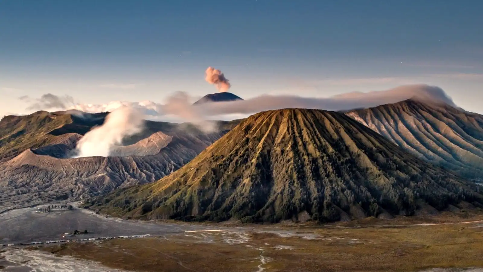
Mount Bromo geology is defined by a rare “caldera within a caldera” structure, situated inside the massive 10-kilometer-wide Tengger Caldera. This landscape formed through a series of colossal eruptions and structural collapses of an ancient 4,000-meter stratovolcano. Today, the Bromo volcanic caldera features five younger volcanic cones, the vast Sea of Sand (Segara Wedi), and a constantly active vent that exemplifies the raw power of the Sunda Arc subduction zone.
- ✅ Formation: Successive collapses of the ancient Tengger super-volcano.
- ✅ Landscape: A 10km wide desert of volcanic ash known as the Sea of Sand.
- ✅ Activity: Frequent phreatic and magmatic eruptions from the main crater.
- ✅ Tectonics: Driven by the subduction of the Indo-Australian plate under the Eurasian plate.
Want to see this geological marvel firsthand? We recommend the Mount Bromo Tour for a complete exploration of the caldera floor.
Table of Contents
The Birth of the Tengger Caldera
Mount Bromo does not stand in isolation. Instead, it is a small part of the Tengger Caldera formation, which is one of the most impressive volcanic complexes in the world. Thousands of years ago, a massive stratovolcano dominated this region, reaching heights similar to the current Mount Semeru.
Catastrophic eruptions eventually caused the magma chamber to empty rapidly. Because the summit could no longer support its own weight, the entire mountain collapsed inward. This event created the massive 10-kilometer depression we see today, providing a perfect stage for Indonesian volcanic history to unfold.
After the initial collapse, volcanic activity did not cease. New vents began to pierce through the floor of the caldera. Over centuries, these vents grew into the five cones currently visible: Bromo, Batok, Kursi, Watangan, and Widodaren. Understanding why Mount Bromo is Indonesia’s most visited volcano starts with this complex and violent architectural history.
A Legacy of Ancient Explosions
Andesitic lava flows characterize much of the base material found here. These rocks indicate that the magma was viscous and trapped high amounts of gas. Pressure builds up in such systems until it releases in spectacular, often dangerous, displays of geological force.
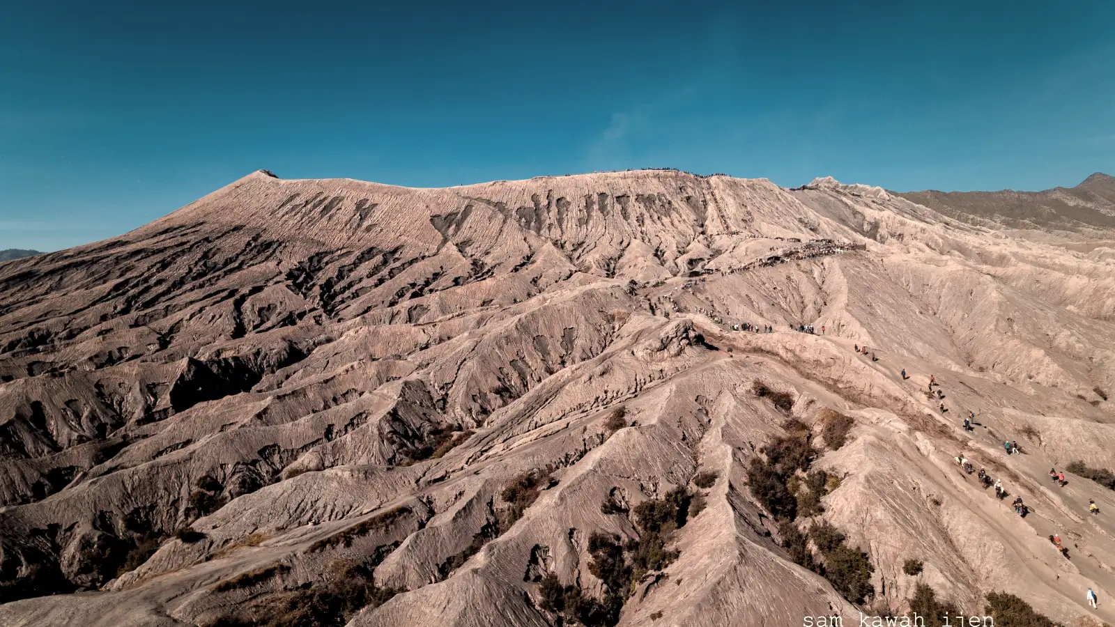
Ash deposits from these ancient events are visible in the stratified layers of the caldera walls. Visitors standing at the King Kong Hill viewpoint can clearly see the horizontal lines marking different eras of volcanic growth. This visual record makes the East Java volcano geology feel like an open-air textbook for those who know what to look for.
Formation of the Sea of Sand (Segara Wedi)
Surrounding the active cones is a desolate, grey expanse known as the Sea of Sand. This 10-square-kilometer desert is unique in tropical Indonesia. While much of Java is lush and green, this specific area remains a barren wasteland of fine volcanic sediment.
The Sea of Sand formation occurred as fine ash and lapilli accumulated on the caldera floor. High-altitude winds trapped within the caldera walls prevent significant vegetation from taking root. Rainwater occasionally carves deep channels into the sand, but the constant deposition of new ash keeps the landscape in a state of perpetual change.
Walking across this terrain reveals the abrasive nature of volcanic glass and crystals. Mount Bromo natural wonders are often gritty and harsh, requiring sturdy footwear and protection from the dust. If you are planning a trip, checking the driving time to Mount Bromo is essential to ensure you arrive when the light best highlights these textures.
🔥 Featured Expedition
Experience the geological wonders of Bromo with an expert guide who brings the history of the Tengger Caldera to life. Our private tours offer the most immersive way to see the sunrise and the active crater.
Aeolian Processes and Ash Transport
Wind plays a massive role in shaping the Segara Wedi. During the dry season, the caldera acts as a wind tunnel, whipping up clouds of fine silica. These particles act like sandpaper, eroding the base of the volcanic cones and keeping the floor flat.
Hydrology also contributes to the desert’s appearance. Because volcanic soil is highly porous, water drains through the sand almost instantly. This lack of surface water makes it impossible for most plants to survive, preserving the alien look of the volcanic landscape in Indonesia.
Inside the Mount Bromo Crater
Mount Bromo itself is relatively small, standing at 2,329 meters. However, its activity level is much higher than many of its taller neighbors. The Mount Bromo crater is a classic somma volcano, meaning a new cone has grown within the ruins of an older one.
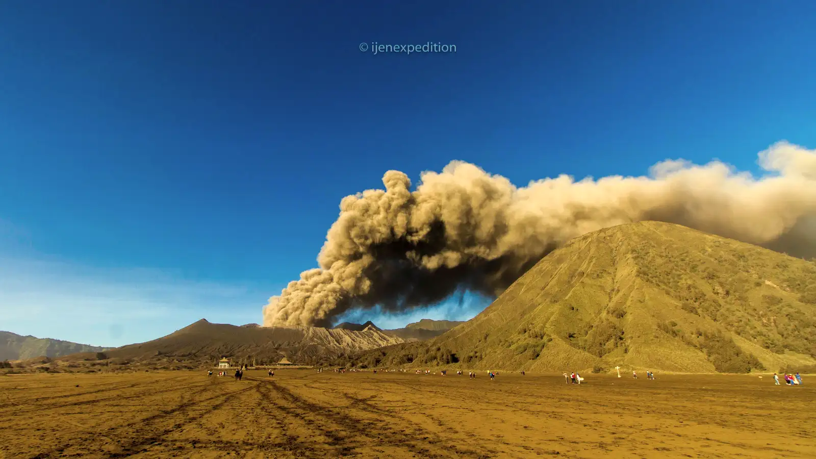
Sulfurous gases constantly billow from the vent. These fumes are a mix of water vapor, carbon dioxide, and sulfur dioxide. Looking into the vent, one can hear the “roar” of the volcano, a sound caused by high-pressure gas escaping through the subterranean plumbing system.
Eruptions here are typically phreatic or phreatomagmatic. These happen when groundwater comes into contact with hot magma, causing a violent steam explosion. Understanding the hike difficulty at Mount Bromo is vital, as the climb to the rim is short but steep and often sulfur-heavy.
Seismic Monitoring and Hazard Mitigation
The Indonesian government monitors Bromo 24 hours a day. Seismographs detect the tiny tremors caused by moving magma. When activity spikes, the exclusion zone around the crater is expanded to protect tourists and locals.
Ash plumes can reach several kilometers into the sky during active phases. These events often disrupt local flights and require residents to wear masks. Staying informed about the last eruption and safety warnings ensures a safe visit to this unpredictable giant.
The Tectonic Engine: Java’s Subduction Zone
The Mount Bromo geology is a direct result of the Indo-Australian plate sliding beneath the Eurasian plate. This subduction zone creates a chain of volcanoes across the Indonesian archipelago. As the oceanic plate descends, it melts, and the resulting magma rises to the surface.
Java’s volcanoes are particularly explosive due to the high water content of the subducting plate. This water lowers the melting point of the mantle, creating gas-rich magma. When this magma reaches the surface, the gas expands rapidly, leading to the “big bangs” that created the Tengger Caldera.
Geologists categorize Bromo as an active stratovolcano. While it may look peaceful from a distance, the tectonic forces beneath it are immense. This constant movement ensures that volcanic activity at Mount Bromo will continue for thousands of years to come.
Comparison: Bromo vs. Neighboring Volcanoes
Logistical Reality: Navigating the Terrain
Visiting a site with such intense East Java volcano geology requires preparation. The terrain is a mix of steep, paved roads, soft volcanic sand, and 250 concrete stairs leading to the rim. If your flight lands at Surabaya Airport at 10 AM, you can typically reach the base of the caldera by 2 PM.
Most travelers arrive via 4WD Jeep. These vehicles are the only practical way to cross the Sea of Sand, as the soft ash can trap standard cars. The dust is fine and pervasive; it will get into your cameras, your clothes, and your lungs if you are not wearing a scarf or mask.
Temperatures drop significantly before dawn. While the hike itself will warm you up, standing at the viewpoint for sunrise can be freezing. Knowing what to pack for Mount Bromo—including layers and windbreakers—is non-negotiable for comfort.
Typical Geological Expedition Timeline
- 03:00 AM: Depart hotel via Jeep to reach the Penanjakan/King Kong Hill viewpoint.
- 05:30 AM: Observe the first light hitting the caldera walls and the Sea of Sand.
- 07:00 AM: Cross the Sea of Sand to the base of Mount Bromo.
- 08:30 AM: Climb the stairs to the active crater rim to hear the volcanic “roar.”
- 10:30 AM: Return to the village for breakfast and to clean off the volcanic ash.
Who Should Skip This Route?
While Bromo is an incredible volcanic landscape in Indonesia, it is not suitable for everyone. The environment is harsh, and the physical demands are real despite the accessibility of the Jeeps.
- People with Chronic Asthma: The sulfur fumes at the crater rim and the constant fine dust in the Sea of Sand can trigger severe respiratory distress.
- Travelers with Severe Knee Issues: The 250 stairs to the crater are steep and often crowded, making the descent particularly taxing on joints.
- Families with Very Young Toddlers: The intense wind, freezing pre-dawn temperatures, and loud sulfurous roaring can be overwhelming and frightening for small children.
- Those Seeking a Quiet, Solitary Experience: Bromo is famous, meaning it is crowded. If you want a “hidden” volcano, this is not the right choice for you.
Why Trust This Guide?
Our team at Ijen Expedition has spent years navigating the volcanic corridors of East Java. We don’t just read about the Tengger Caldera formation; we walk it daily. Our guides are trained to understand the subtle shifts in volcanic activity and weather patterns that only locals can recognize.
We prioritize factual integrity and safety. From monitoring the latest PVMBG alerts to knowing the exact moisture levels of the Sea of Sand after a rain, our field experience ensures you get an objective view of the mountain. We believe in showing the volcano as it is—raw, dusty, crowded, and utterly magnificent.
Continue Your Adventure
If the Mount Bromo geology has piqued your interest, there is much more to see in the region. Many travelers combine their visit with other volcanic wonders or extend their stay to explore the surrounding waterfalls and parks.
- 🌟 Mount Bromo Midnight Tour – Perfect for those on a tight schedule leaving from Surabaya.
- 🌟 2-Day Bromo Exploration – A slower pace to truly appreciate the caldera floor.
- 🌟 Bromo & Ijen Duo – The classic East Java route ending in Bali.
- 🌟 East Java Tour from Bali – Convenient transit for travelers coming from the Island of the Gods.
- 🌟 The Ultimate Waterfall & Volcano Loop – Includes Tumpak Sewu, the most impressive falls in Java.
Frequently Asked Questions
Is Mount Bromo dangerous to visit?
Bromo is an active volcano, but it is generally safe for tourism. The authorities maintain an exclusion zone that expands or shrinks based on current seismic activity. Always follow the instructions of your local guide and park rangers.
How was the Sea of Sand formed?
The Sea of Sand was created by the accumulation of volcanic ash and debris inside the massive Tengger Caldera. High walls trap the sediment, and lack of water prevents vegetation, creating a unique desert environment.
Can you actually see lava inside Bromo?
No, you typically only see thick white sulfurous smoke and steam. Bromo’s magma chamber is deep underground. During high activity, you might see “incandescence” (a red glow) at night, but flowing lava is very rare.
Why is the landscape so different from Bali?
While Bali is also volcanic, the Tengger region has experienced more recent, large-scale caldera collapses. This creates a “somma” landscape that is more barren and higher in altitude, leading to a drastically different ecosystem.
When is the best time for geological photography?
The dry season (May to September) is best. The lack of rain ensures the dust creates beautiful atmospheric hazes during sunrise, and the shadows on the caldera floor are most dramatic.
Ready to See Bromo’s Geology?
Don’t just read about the history—walk the Sea of Sand and stand on the crater rim with the experts. Book your private geological expedition today.